|
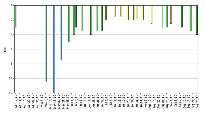
2010 Secchi transparency data (chart above) East Bay monitoring site.
|
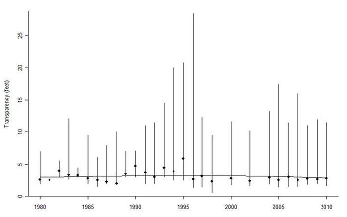
Watershed Transparency Trend West Bay monitoring site (see chart above)
Watershed trend analysis result: In this watershed, the median transparency increased by 0.00 feet per decade. Of the 52 lakes in this watershed with sufficient data to test for a trend; 8 lakes had a good evidence for an increasing trend and 2 lakes had good evidence for a decreasing trend. In 2010, the median transparency across the 68 lakes with data was 5.12 feet; at this lake, it was 2.79 feet. This lake was higher than 15 lakes and lower than 51 lakes..
|
Lake Transparency Trend East Bay monitoring site (see chart above)
Trend analysis result: The median transparency at this lake from 1973 to 2010 decreased by 0.07 feet per decade. Given the variability over these years, this is evidence for a long-term trend. A plausible range for the long-term trend is between no trend and a decrease of 0.31 feet per decade.
Watershed Transparency Trend
Watershed trend analysis result: In this watershed, the median transparency increased by 0.00 feet per decade. Of the 52 lakes in this watershed with sufficient data to test for a trend; 8 lakes had a good evidence for an increasing trend and 2 lakes had good evidence for a decreasing trend. In 2010, the median transparency across the 68 lakes with data was 5.12 feet; at this lake, it was 2.95 feet. This lake was higher than 18 lakes and lower than 48 lakes..
|
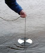 |
| secchi disc |
|
CITIZEN LAKE MONITORING PROGRAM - WATER CLARITY
2011 MPCA-CLMP volunteers for lake Sarah are Mike Peterson (west bay) and Brad Spencer (east bay).
The secchi disk is a measure of water clarity. The standard secchi disk is a 8 inch diameter metal plate that is painted with an alternating white and black color pattern. The disk is lowered into the water until it disappears from view. The depth at which the disk can no longer be seen is the secchi depth that is recorded. Secchi disk readings can vary by season with the clearest water generally occurring in the spring, shortly after ice-out.
The Minnesota Citizen Lake-Monitoring Program uses the all-white Secchi disk described by Shapiro et al. (1975). The volunteer is asked to make readings between 10 a.m. and 3 p.m. on bright, calm days. The disk is lowered over the shady side of the boat and the volunteer is asked to remove sunglasses. The depth of disappearance and reappearance of the disk is averaged, and the depth is measured to the nearest 1/2 foot. The line is marked. Dacron, or other polyester material, is recommended for the line because nylon has a tendency to stretch when wet, as well as being adversely affected by repeated exposure to sunlight.
|
|
Stormwater Calculator
The Chicago-based Center for Neighborhood Technology has created a simple web-based tool that quantifies the reduced runoff and cost of using alternatives to curbing and piping stormwater offsite. While larger cities have engineering staff who use more sophisticated tools, this one is useful for towns, homeowners and citizen volunteers on municipal committees. Go to http://greenvalues.cnt.org/calculator. Choose from six "green interventions" such as using porous pavement on driveways and sidewalks. Then choose a development scenario such as suburban new development. Finally fill in 12 factors such as size and slopes. The calculator then produces extensive financial and hydrologic details such as: Total peak discharge reduction, first year and 100 year comparative costs and benefits, present value and per-lot financial detail, maintenance detail, C02, air pollution and groundwater benefits.
Toxic Algae blooms can be dangerous to your pets! Blue-green algal blooms are making an early and intense appearance this year on many lakes including here on Lake Sarah! MPCA has been responding to numerous calls of severe blooms from lake residents across the state, as well as at least one veterinarian-documented dog death that was directly attributed to a dog drinking water from a lake with an extensive bloom. Given our current hot and dry conditions we can expect severe blooms to continue on many of our area lakes as the summer progresses -- in particular many of our nutrient-rich lakes across central and southern Minnesota. The MPCA has information on blue-green algal blooms and what to watch out for on their web site at: http://www.pca.state.mn.us/water/clmp-toxicalgae.html. Also there is a new technical report that looks at the concentration of Microcystin, one of the algal toxins of concern, in several south central MN lakes: http://www.pca.state.mn.us/publications/reports/wq-lar3-11.pdf.
Minnesota Waters announces the availability of its new publication�A Citizen�s Guide to Influencing Local Land-Use Decisions�written in collaboration with 1000 Friends of Minnesota. The 52-page booklet was written to create a well-informed, well-organized, well-prepared citizenry ready to address increasing shoreland development proactively, instead of reactively, in the name of balanced, well-planned growth and development. To receive a copy, send $5, to cover postage and handling, to Minnesota Waters: 17021 Commercial Park Drive #4, Brainerd, Minnesota 56401
Lake Sarah has been added to the 2006 Impaired Lakes List. The successful appeal to the MPCA to have Lake Sarah reconsidered and recommended for addition to the proposed 2006 MPCA Impaired Lakes list for excess nutrient levels has now been confirmed. Lake Sarah had originally been left off the biennial list due to lack of water quality testing data. Howard Markus has confirmed that Sarah will be on the final draft of the 2006 list that will go to the EPA. Thank you to Steve Heiskary, Jennifier Oknich, Bob Murzyn, Jim Porter and Howard Markus at the MPCA as well as Brian Vlach & John Barten at Three Rivers Park District for all their help in getting lake Sarah's data into STORET, analyzing and reviewing the data, and lobbying for Sarah to be added to the final list. This Impairment designation is important in the effort to seek funding for a TMDL study and for possible assistance in efforts to improve overall water quality. More information can be found on the TMDL project page.
|
|
Starting Monday, September 25th and running to October 29th, a stormwater pollution prevention public service announcements (PSA) is airing on cable television stations throughout central Minnesota and western Wisconsin. (click on the blue link above to view the short video). It is based on the "rubber ducky" PSA produced by the City of San Diego and modified to fit Minnesota conditions. Outdoor personality Ron Schara of "Minnesota Bound" fame is providing the voice. The PSA "buy" was designed to target "do it yourself" homeowners who are most likely to be doing yard work. The final message is "rake up, sweep up, and pick up for cleaner water. "Minnesota Water - Let's Keep It Clean", a stormwater education collaborative of cities, counties, watershed districts, and businesses, developed and financed the PSA.
The Lake Water Quality Project at the Minnesota Pollution Control Agency is an annual assessment of 2.235 lakes within Minnesota (includes Lake Sarah). Lake water quality assessment information is useful to anyone involved in lake management from lakeshore owners to lake associations. It provides lake water quality criteria, which can improve how we manage our lake resources and how we measure current conditions. It also providess a knowledge base that we can use to protect and restore our lakes. In order to help citizens interpret the data from the Lake Quality Project, the MPCA and the Freshwater Society produced a 31 page publication entitled A Citizens' Guide to Lake Protection. Click on this link to download the publication in .pdf format. please be patient the file is large - 5.8Mb.
The Lake Sarah project - In the early 1990�s, the Commission undertook the Clean Water Partnership Project with the Hennepin Conservation District (HCD) at Lake Sarah. The Diagnostic Study Report and Implementation Plan were published in December of 1996. Details and reports produced by this study can be found on this website on the HCD Project page.
|
|