| Macrophyte Studies (point intercept) |
In 2012 (and in several previous years) the Three Rivers Park District, Department of Water Resources performed an early and late summer Aquatic Vegetation Study for Lake Sarah (MN DNR 27-0191) in Hennepin County. The data from those studies have been summarized and can be viewed in the downloadable spreadsheet Percent Frequencies 2012 as provided by Rich Brasch, Senior Manager of Water Resources. The occurances of Lake Sarah's primary aquatic invasive plant species; Curly-leaf Pondweed (CLP) and Eurasian Watermilfoil (EWM), are presented below in map form segmented as East Bay and West Bay with the June sampling above the August sampling for direct comparison.
TRP staff note CLP senescence prior to survey so may not acurately reflect densities at peak of growth cycle.
Thank you to Rich Brasch and the staff at Three Rivers Parks for their continued work towards improving our lake's water quality and for supplying this data!
|
Curly-Leaf Pondweed 2012 point intercept study maps by Three Rivers Park District.
West Bay sampled June 8 and August 15, 2012
East Bay sampled June 7 and August 15, 2012
click on maps below for larger image. June map top, August map bottom.
|
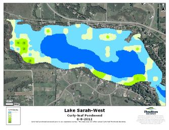 |
| CLP 6/8/12 West Bay |
|
|
 |
| CLP 6/7/12 East Bay |
|
|
 |
| CLP 8/15/12 West Bay |
|
|
 |
| CLP 8/15/12 East Bay |
|
|
Eurasian Watermilfoil 2012 point intercept study maps by Three Rivers Park District.
West Bay sampled June 8 and August 15, 2012
East Bay sampled June 7 and August 15, 2012
click on maps below for larger image. June map top, August map bottom.
|
 |
| EWM 6/8/12 West Bay |
|
|
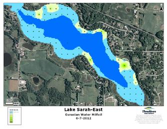 |
| EWM 6/7/12 East Bay |
|
|
 |
| EWM 8/15/12 West Bay |
|
|
 |
| EWM 8/15/12 East Bay |
|
|
Charts from the Macrophyte (point intercept) Studies completed in 2009 and 2011 by Three Rivers Park District. Native and Invasive species Vegetation scored by percent occurrance.
|
|